What is currently happening on the Rail Trail?
Significant progress has been made securing the land, designing the rail trail, establishing the development plan, raising funds, and constructing sections.
It is very technical work and socially complex. Extensive consultation was completed regarding laying down the trail surface, keeping erosion at bay, channeling flood water, taking care of the environment, protecting cultural values, ensuring agricultural operations are supported, addressing safety at road crossings, rock-scaling cliffs, creating parking areas, and designing signage.
The Rail Trail partners have been able to raise $15.1 million in funding support from the Provincial and Federal Government along with matching funds from rail trail reserves and support from the District of Sicamous and Columbia Shuswap Regional District Electoral Area E Economic Opportunities Fund for construction.
Additionally, a community led fundraising campaign has been able to raise over $300,000 in donations including a $100,000 sponsorship from Askews Foods, $50,000 from SASCU, and $10,000 from the Rotary Club of Salmon Arm.
This is sufficient to substantially construct the rail trail between km 0.0 and 42.6 at Stepney X Road, as well as km 49.15 at Lansdowne Road to km 50.15 in Armstrong along the still active rail line. Several sections have been completed and are open to the public, with other sections awaiting further construction.
Efforts are now underway to secure the final funds needed to complete the final 6.5 kilometre section of the rail trail between km 42.6 and 49.15 within the Township of Spallumcheen. This section requires the construction of a pedestrian/bicycle overpass of Highway 97A at Stepney Road.
For an update on access and maps to sections of the rail trail open to the public, and news of construction progress, closures, and delays: Download the latest information bulletin
What will the surface of the trail be?
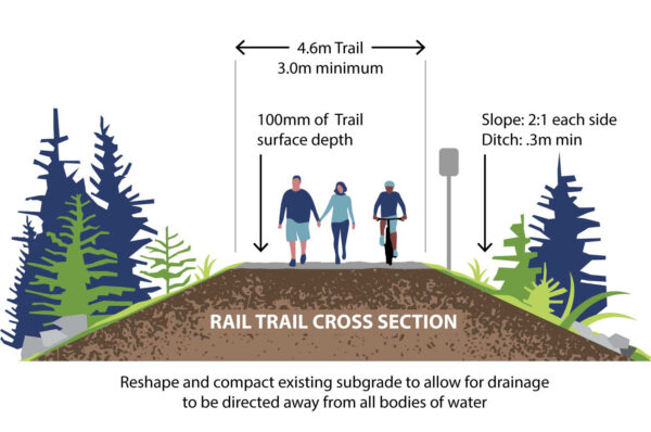
The finished surface will consist of crushed and compacted aggregate, suitable for pedestrian and off-road bicycle use, as well as universal mobility access.
Dogs on leash are welcome.
No motorized vehicles or equestrian use. Pedal assist e-bikes will be allowed.
Cyclists are asked to keep their speeds to 30 km/hour or less and yield to pedestrians.
What is the overall concept for the Rail Trail?
The Shuswap North Okanagan Rail Trail links communities from Sicamous to Armstrong and provides an opportunity to unfold the true story within the Secwépemcúĺecw (Secwépemc Nation territory) focusing on sharing culture, values, and relationships. The Splatsin are a leading partner in the Rail Trail initiative, bringing both local government and first nations together to work collaboratively towards a common goal of uniting communities and connecting with the land.
The Shuswap North Okanagan Rail Trail Development Plan can be viewed here.
The Public Information Display Boards provide an overview of the project.
What is the Agricultural Land Commission consultation process?
The ownership partners have received the formal decision from the Agricultural Land Commission (ALC) allowing a change of use for the former CP Rail Corridor to public greenway trail with conditions. More details are available here.
A copy of the ALC Decision can be viewed on the ACL Application Portal website (application 60525)
The background presentation on the ALC process for the rail trail is available here.
The ALC must provide final approvals for construction of the rail trail to proceed within the Agricultural Land Reserve between km 15 and km 49.15 the ALC. See the latest information bulletin link above for updates.
How is the rail trail funded?
The Splatsin te Secwépemc/Shuswap North Okanagan Rail Trail is a joint project of the Splatsin te Secwépemc, Regional District of North Okanagan (RDNO) and the Columbia Shuswap Regional District (CSRD) with funding assistance from the Province of BC and Government of Canada.
Acquisition involved Splatsin negotiating purchase of two sections of the railway corridor with CP Rail in 2015. Then in 2017 the CSRD and RDNO jointly committed to borrow funds through an alternate approval process with matching commitment from the Province of British Columbia to purchase the remaining railway corridor from CP Rail.
Development planning was made possible through grant funding from the BC Rural Dividend Program and matching leverage funds contributed by the CSRD Area E/Sicamous Economic Opportunities Fund and the District of Sicamous.
Construction of the rail trail has been made possible through funding from the Government of Canada and the Province of British Columbia, the Thompson Okanagan Tourism Association, and leverage funds contributed by the CSRD Area E/Sicamous Economic Opportunities Fund and CSRD/RDNO rail trail reserve funds.
Additionally, a community led fundraising campaign has been able to raise over $300,000 in donations including sponsorship from Askews Foods, SASCU, and the Rotary Club of Salmon Arm. These funds are administered through the Shuswap Community Foundation together with the Community Foundation of North Okanagan.
Funding for the ongoing maintenance and operational management of the rail trail will be shared by Splatsin te Secwépemc, Regional District of North Okanagan (RDNO) and the Columbia Shuswap Regional District (CSRD) governments. Additional support through grants, when available, and community led fundraising will also continue to support the rail trail.
Download the latest Financial Summary Report.
How is the rail trail governed?
The Splatsin te Secwépemc, Regional District of North Okanagan (RDNO) and Columbia Shuswap Regional District (CSRD) have entered into a joint agreement to develop, operate, and maintain the rail trail in partnership together.
A joint Governance Advisory Committee (GAC) representing the three partners is overseeing the project, a Joint Rail Trail Roundtable provides update reports to all the member jurisdictions through elected representatives, and a Technical Operational Committee with staff from each of the partners including Splatsin Title & Rights and the Splatsin Development Corporation is conducting the day-to-day work of developing, operating, and maintaining the rail trail.
Download the Governance Advisory Committee (GAC) Terms of Reference (including Joint Rail Trail Roundtable) and the Technical Operational Committee (TOC) Terms of Reference.
Download the infographic on decision-making roles and responsibitities for the rail trail.
Download meeting minute links to the Governance Advisory Committee & the Joint Rail Trail Roundtable.
Who is maintaining the trail?
The Splatsin te Secwépemc, Regional District of North Okanagan (RDNO) and Columbia Shuswap Regional District (CSRD) jointly maintain the rail trail in partnership together.
The Splatsin Development Corporation’s Yucwmenlúcwu (Caretakers of the Land) are the project construction management lead, and the day-to-day maintenance lead.
How do I report a trail maintenance issue?
Assist us in reporting rail trail issues through the online Shuswap Trails Trail Report form, or email: trailreport@shuswaptrails.com (clear location descriptions and photos of the issue really help).
Will there be opportunities for volunteers?
Yes. Opportunities for volunteer support will be part of the ongoing stewardship of the rail trail. Already, volunteer days have been hosted by the Columbia Shuswap Invasive Species Society along the rail trail corridor to assist in the removal of invasive plants.
Sign up to the rail trail e-bulletin to keep up to date.
What’s next?
Splatsin, RDNO, and CSRD continue to construct the trail as approvals, permits, and capital funding allows.
Further work will include adding trailhead gateway kiosks, additional amenities, interpretive signage and restoring vegetation along the corridor. Standards for vegetation restoration and landscaping have been developed. This includes addressing invasive plants.
We want to remind property owners and the public that there should be no alterations whatsoever to plants and vegetation along the corridor without authorization from the owners.
For the public’s safety, obey all signs and notices, and stay out of rail trail sections that are closed or under construction. Trespassers may be subject to enforcement fines and other penalties.
For an update on access and maps to sections of the rail trail open to the public, and news of construction progress, closures, and delays: Download the latest information bulletin
Who should I contact with questions?
Please contact your local government rail trail partner at either:
Splatsin te Secwépemc at 250-838-6496, www.splatsin.ca
Regional District of North Okanagan Community Services at CommunityServices@rdno.ca or phone 250-550-3700, www.rdno.ca
Columbia Shuswap Regional District at 250-832-8194, www.csrd.bc.ca